After a succession of setbacks
Ranger 7 launched from Cape Canaveral on July 28, 1964. The program had already experienced misses, failures and the especially disappointing Ranger 6 mission, which reached the Moon without returning the desired pictures. The new spacecraft had a deliberately limited assignment: activate television cameras during final approach and transmit until collision. There was no plan to preserve it afterward. Impact completed the chosen trajectory. Its destruction should consequently not be described as an unexpected accident or a mysterious disappearance of communication with an otherwise functioning lunar explorer.
The cameras start transmitting
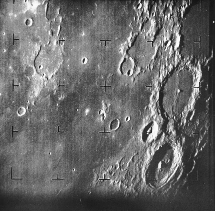
Following a course correction on July 29, the spacecraft approached along its intended route. On July 31 the cameras operated and signals began reaching Earth. NASA accounts generally describe approximately seventeen final minutes of imaging, while some short summaries round the interval differently. Early frames included broad terrain and craters familiar from ground observations. Each later frame covered a smaller area. That nested sequence, rather than one spectacular picture, connected the Moon's familiar distant appearance with newly visible terrain at scales useful for planning a landing.
Six views of the surface
Six television cameras provided different fields of view and imaging modes. LPI describes the system's independent channels and overlapping coverage. The arrangement supplied both context and detail. As the surface approached, small craters, irregularities and the texture of lunar plains became visible. This was practical information for landing planners: smoothness seen from far away could conceal hazardous topography. The photographs did not directly measure the ground's mechanical strength. They nevertheless moved assessment from broad lunar geography toward the physical appearance of particular surface areas that future missions might examine.
The final frame and the impact
Transmission ended with impact at 13:25:49 Universal Time. The region between Oceanus Procellarum and Mare Nubium became known as Mare Cognitum, the Known Sea. This entry uses LPI's historical position, approximately 10.35 degrees south and 20.58 degrees west. Other reference works give somewhat different coordinates, requiring an explicit precision qualification. The last image marks a physical boundary to observation: the spacecraft transmitted the approaching terrain until collision destroyed its cameras and radio equipment. The abrupt ending completed the intended sequence rather than interrupting an attempted soft landing.
Thousands of frames and different totals
NASA Science's modern summary gives 4,316 pictures, whereas JPL and NASA's anniversary history give 4,308. Stating that discrepancy is preferable to implying an uncontested single counter. Both figures describe a large successfully received sequence. LPI's archive offers photographic publications organized by camera together with supporting documentation. For examining a particular frame, that structure is more useful than a rounded mission total. It allows readers to check provenance, position within the sequence and the terrain shown instead of depending entirely on a later popular account of the mission.
Comparing the results
Operational histories, mission summaries and the image archive agree on the central sequence: the cameras operated, data arrived and a planned impact ended the flight. Frame counting and historical mapping deserve care without making the success itself doubtful. Ranger 7 did not demonstrate that every lunar location was ready for a human landing. It substantially reduced uncertainty about the terrain of selected plains and helped prepare subsequent orbital and surface investigations. The mission illustrates how a short flight with an irreversible ending could produce a checkable image collection rather than a solitary claim about a distant world.