A hemisphere without an Earthbound observer
Before spaceflight, the lunar far side could not be photographed directly from Earth. Tidal rotation keeps approximately the same hemisphere facing our planet. Small librations reveal areas near the edges, but not the central regions of the opposite side. After achieving an impact, the Soviet program pursued a different objective: fly around the Moon and look back. The October 4, 1959 launch followed Luna 2 by only weeks, but this probe had to survive the encounter, aim a camera and transmit pictures instead of crashing.
A route to the illuminated hemisphere
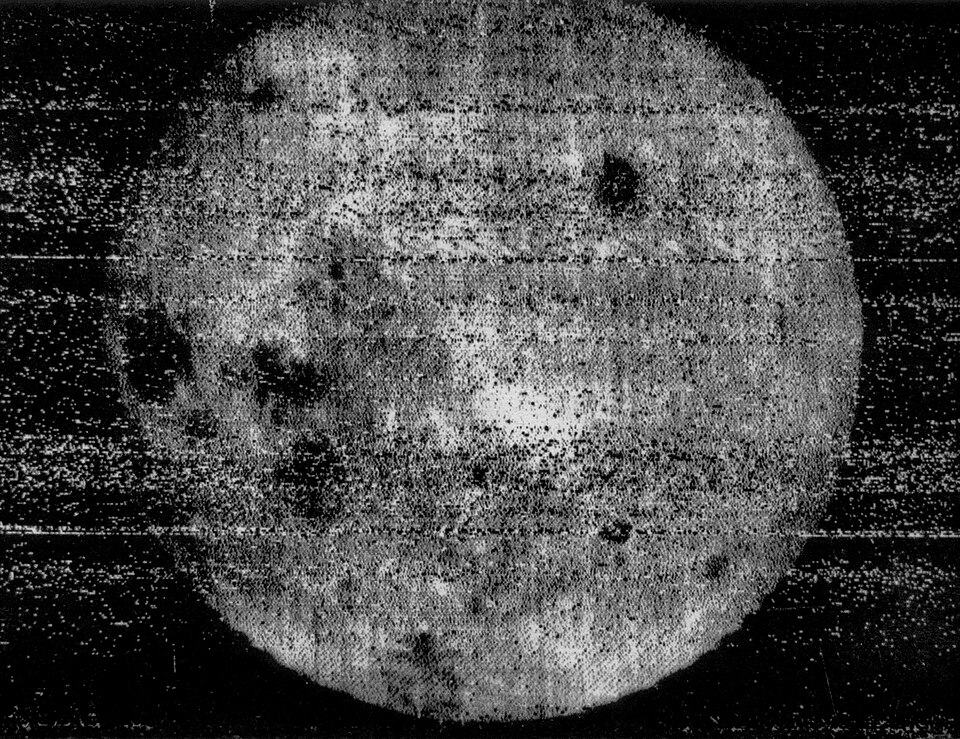
On October 6 Luna 3 passed near the Moon's southern region and reached a position from which it could photograph the hemisphere hidden from Earth. Imaging began on October 7. NASA gives 03:30 UT and a range of approximately 63,500 kilometers for the first exposure. The session produced 29 photographs covering around seventy percent of the far side. The distinction between closest approach and the first exposure explains why abbreviated timelines contain both dates. The illuminated terrain also demonstrates why the familiar expression 'dark side' is misleading.
The photographic laboratory flew with the camera
This was not a modern digital imaging system. A dual-lens camera exposed 35-millimeter film, which was processed aboard the spacecraft. The developed pictures were scanned and converted into a radio signal resembling facsimile transmission. Image quality therefore depended on optics, exposure, chemical processing, scanning and radio reception together. Specialists on Earth received noisy material, but the noise did not erase all spatial information. The important technical transition was that a photograph could be made where nobody had traveled and return without physically bringing back its film.
What the first pictures revealed
The photographs showed a hemisphere strikingly different from the familiar Earth-facing view. Large dark plains were much less extensive, while bright rugged terrain occupied more of the visible area. Some individual features could be recognized despite the low resolution, beginning the process of mapping and naming. Yet an early photographic map did not provide today's knowledge of composition or internal structure. A dark patch could suggest a geographical interpretation, but not justify a claim of construction. Later orbiters refined the geography and made the earliest interpretations testable.
From receiver to museum print
The pictures quickly became international news. The Metropolitan Museum holds a 1959 print associated with TASS and United Press International and explicitly describes it as blurry and heavily retouched. Press preparation made its patches easier to distinguish; this print documents circulation of the discovery but cannot neutrally replace the original signal. NASA later compared the first view with Lunar Reconnaissance Orbiter measurements. Their differing detail reflects half a century of instrumental development. It does not mean that the craters appeared between exposures or that the earlier probe saw a different world.
Comparing the images and conclusion
NASA's description establishes timing, distance and coverage. The museum record traces a particular printed version, while modern mapping provides independent geographical checks. These sources answer different questions and complement each other. The established achievement is the first photography of the far side, rather than the infallibility of every early label. Unusual outlines in coarse imagery should be compared with scale, noise and later topography. The central mystery here was geographical, and successive observations gradually transformed it into a map that other observers could test.